Month: September 2020

Global Energy Flows 2018/2050, DNVGL

Fresh off the press last week is DNVGL’s Energy Transition Outlook 2020. This report is a “forecast of the world’s most likely energy future through to 2050” and in my opinion this is really good information. The new edition already factors in the effects of the pandemic.

The spread on pages 122/123 has the following Sankey diagrams, a comparison of the global energy landscape in 2018 and the forecast for 2050:


The individual flows are not labeled with quantities, but we get an idea from the blue stream, that represents 27 PWh/yr electricity in 2018 and 60 PWh/yr in 2050. “One striking change on the supply side of the picture is the emergence of solar PV and wind at the expense of coal and oil. Electrification more than doubles through to 2050, which leads to an increase in the overall system efficiency.”

Make sure to download your copy of the DNVGL Energy Transition Outlook 2020, to study the global energy flow Sankey diagram in more detail.

Material Flow Analysis for Almaty

Almaty is the largest city in Kazakhstan. It is also the first city in Central Asia that did a circular economy opportunities analysis. Numerous ideas were proposed during a project with local stakeholders.
The project is described on the Shifting Paradigms blog, and the full report ‘Metabolic analysis and circular economy strategies for Almaty, Kazakhstan’ describing the project can be downloaded there.

Visuals turned out to be crucial in this project for communicating information and to be able to oversee the amount of data. “Mapping out the metabolic system of a city, helps understand how a city uses material resources to deliver valuable services to its inhabitants, like nutrition, shelter and mobility, and identify opportunities for improvement.”

This is the Sankey diagram depicting the material flows for Almaty, Kazakhstan covering minerals, metals, biomass, fossil fuels, energy and water used in Almaty’s industry. It is shown on pages 36/37 of the report. Flows are in kT (per one year ?) with imports/exports across the city’s boundaries.

Blended into this material flow analysis (MFA) diagram are greenhouse gas emissions (GHGs). “The red flows at the lower section of the graph show the embedded gas emissions in imported goods and materials.” These could be considered hidden quantities associated with the production of products or the import of fuels, “piggybacking” on the actual physical material flows that enter and leave the industrial sector in the city.

Note that it seems as if flows are not always to scale or parts are hidden behind other flows (see, for example, the yellow stream representing 968 kT of fuel being turned into 2,975 kT GHGs, a flow that is not three times as wide). Also the recycling flow width seems to overblown, probably to point out that recycled materials can loop back through the system multiple times, and to focus the circular economy perspective.

There are two other Sankey diagrams in the report, so make sure you have a look at it.

France’s Grand Est Region Energy Flows

Le Grand Est is a French administrative region in the north-east of the Hexagone, comprising Alsace, Champagne-Ardenne, and Lorraine. ATMO Grand Est is a not-for-profit, government-backed association that is monitoring air quality in the region and looking at ways to improve it.

As part of their work they have prepared energy flow diagrams, not only for the whole region, but also on the communal level. More than 100 Sankey diagrams, depicting the energy flows and the use of energy are available on the ATMO website. Visit the resources section and check “Diagrammes de Sankey” in the filter list at the right.

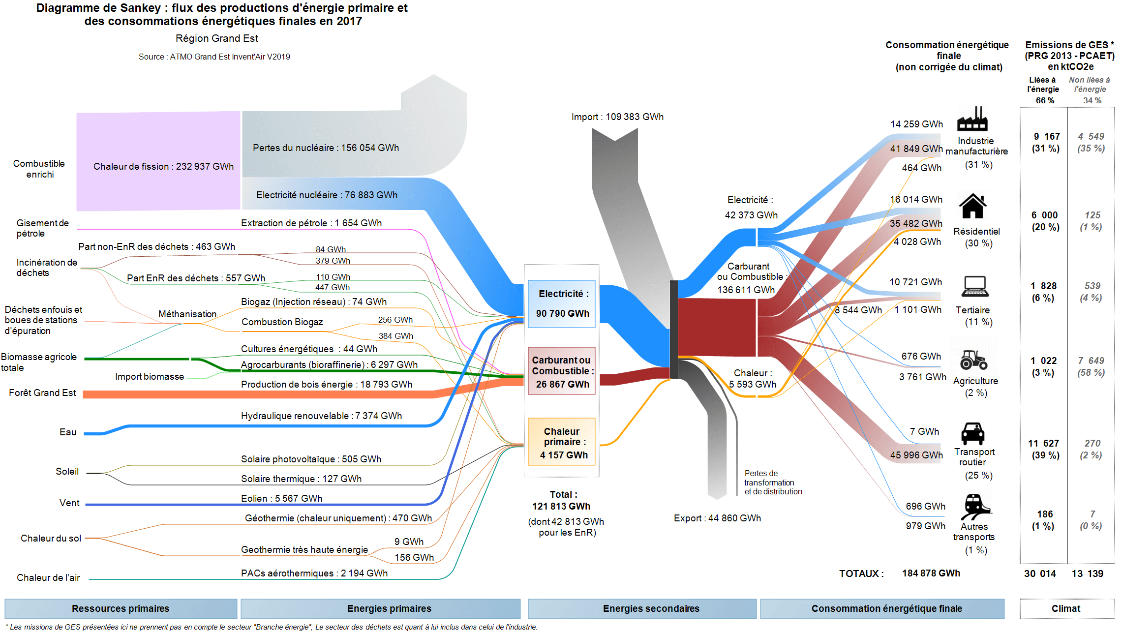
Here is the figure for the overall region with energy consumption and use in Grand Est in 2017. Flows are in GWh.


On the left we see primary resources, with the largest source being nuclear fuel. With an efficiency of only 33% this still delivers most of the secondary energy consumed in the Grand Est region. The grey stream from the top are “imports” to the region, most likely from other parts of France (or from neighboring Germany). The energy consuming sectors are shown on the right. A table next to them points out the GHG emissions linked to the energy.

Each of the individual Sankey diagrams for the CCs (communauté de communes, rural communities) and some CAs (communauté d’agglomération, semi-urban communities) available have exactly the same structure, but they can look strikingly different.

Here is one example from CC Portes de Meuse, a community with just over 17,000 inhabitants


CC Portes de Meuse can apparently cover three-quarters of their energy demand from wind and wood, with only 25% being imported. (Not sure though how they can have 260 GWh energy use in road transport, unless most vehicles are already electric).

Note that although both Sankey diagrams have a similar structure and flows are both in GWh in 2017, this diagram mustn’t be compared directly to the one above in regard to the width of the arrows, since they are on a different scale.

Great work by ATMO Grand Est, and I am sure these visualizations are useful when discussing energy consumption, GHG and air pollution among stakeholders in the communities or the region. They have already announced the Invent’AIR v2020 version to be published in the near future.